Modern day Folly Island
Folly Island is situated in the centre of Hertford where the River Lee (or Lea) splits into two. Hertford is the county town of Hertfordshire. It has a bus station, two train stations and easy access to most major road networks to London and airports.
There are 122 houses on Folly Island. They are two or three bedroom, mid-terrace cottage style homes built in the last years of the nineteenth century by the Andrews and Thornton families.
The absence of through traffic, the closeness of the town centre and the open spaces of Hartham Common nearby adds to the attraction of the Island as a place to live.
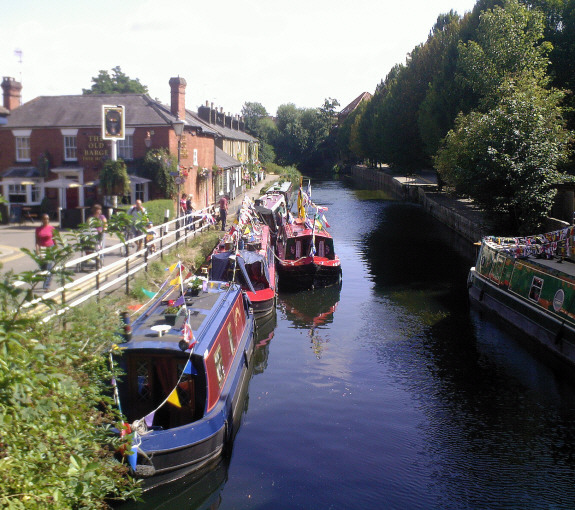
There is also a pub – The Old Barge, a freehouse which can be found in CAMRA and serves a wide range of real ales, ciders, export lagers and food until late seven days a week.
The Good Beer Guide from Amazon
There is only one access for vehicles over Folly Bridge close to Lombard House at the northern end of Bull Plain.
Folly Island is designated a Local Conservation Area and cherry trees planted along Thornton Street recreate an original feature from the end of the last century.
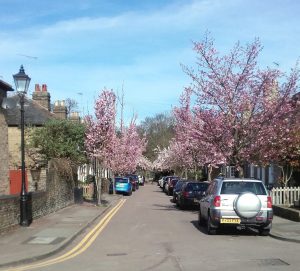
This photo (above 17 March 2017 ) shows how attractive parts of Folly Island look in early spring when the first blossoms burst into life.
For those interested in how Folly Island looked in more recent times (1976) see my page – ‘Folly Island, now and then‘ with views from the past revisited today.
History of Folly Island
Although Folly Island is formed by the two streams of the River Lea it is not a natural island. In 1699 it was joined to the mainland at Dicker Mill where the main river ran through the centre of town and powered the mills and along the northern side of Folly Island. Here it split and to the south ran a smaller stream where the water levels were insufficient for the increase in working mills. Most relocated further downstream and formed what is now Dicker Mill to the east.
The River Lea actually features in a song of the same name by Adele on her ’25’ album.
‘When I was a child I grew up by the River Lea
There was something in the water, now that something’s in me.’
The stream was eventually widened and improved in the eighteenth century with the passing of the Navigation Acts to accommodate the increase in barge traffic that needed to access the centre of town.
In 1699 the piece of land that connected Folly Island at Dicker Mill was demolished in the middle of the eighteenth century in order to allow easier passage for barge traffic. From this time Folly Island became a true island.
The history of Folly Island begins in the days of William the Conqueror when a mill was built on the site of a priory close to modern day Priory Street. In 1636 the mill was relocated down stream to where the Dicker Mill Industrial Estate is today as other mills closer to the centre of town took more water for their own workings.
A 1700 map of Hertford shows Folly island as an open space between the two branches of the River Lea and split into three separate parcels of land; Old Hall Mead (Old Hall Street is named after this), Little Hartham and Priory Orchard, now cultivated as allotments.

This map also shows a small footbridge connecting the Priory to the Orchard. This has long since been demolished.
The earliest recorded use of the ‘the Folly’ (the street called The Folly runs from Folly Bridge to the crossroads with Thornton Street) was in 1732 when Little Hartham was conveyed by Thomas Ashby to John Nicholson. It was referred to as ‘Ashby’s Folly’; that small piece of land was later to be the site for a militia hospital and a dumping ground for the waste from Hertford goal.
The transfer of the lease to Nicholson signalled a dramatic increase in the development of commercial interests on the adjoining stretch of the island. Late nineteenth century maps show an abundance of maltings, timber mills and warehousing operations.
The River Lea was the dominant inland route for the transport of malt and barley, tapping into some of the richest barley country in Hertfordshire, most especially around Ware, Hoddesdon and Stanstead Abbotts. Hertford’s great rival Ware prospered to become the centre of England’s malting industry.
For a more detailed history of the island see Rosemary Bennet’s excellent ‘Folly Island’ – not in print but copies can be obtained from Hertford Museum and some on-line second hand book stores.
Centre of the malting industry
The Navigation Act of 1738 was of such importance to the prosperity of Hertford that the corporation paid ten shillings for the bells to be rung. It enabled the then mill stream to be widened and navigation improved to allow barges right into the centre of Hertford and alongside the mills rather than along the course of the old river.
Although it was essential for the malt to be transported down to London the River Lea also opened up opportunities for barge owners to return from London with coal, dung to fertilise the market gardens along what is now the A10 corridor; and animal feed for the continuing reliance on horse drawn transport.

For many years the only access to Folly island was over a footbridge at Bull Plain.
Mill owners successfully applied for the widening of the bridge to allow carts but the high sides still made getting goods off the island easier by barge than by road.
The narrowness of the bridge was as much the reason for the decline in the Folly as a trading centre as the coming of the railways.
Movement by barge was still far cheaper but the repeal of the Corn Laws in 1846 had reduced the price of corn and encouraged large landowners to sell off land to commuters that sought the green fields of Hertfordshire.
Now Folly Island is a modern residential area. Residents and visitors still stand on Folly Bridge to capture the iconic view. Such as this taken one late misty, cold autumn evening.
© John Barber. First published in Hertfordshire Countryside, August 2000.
More articles on Hertford:
Hertford the county town, Folly Island, Hidden Hertford, Old Barge Pub, Brewing in Hertford, Easter, Fore Street, Eccentric Clergy, Hertford Library, Hertford 1861, Tunnels of Hertford, Sarah Stout, Closed pubs