Here is a time shift view of certain parts of Folly Island in about 1976 and now (July 2018).
The original photos were given to me by Cllr Peter Ruffles about 16 years ago. I cannot be too sure about the date he took the photos but the accompanying descriptions points to a time about 1976 or maybe a year or two earlier.
The Folly


The four end terrace houses were numbered 22 to 28 The Folly. They were identical to the others. However in 1976 they were condemned and demolished owing to a large hole appearing in the back gardens.
They were rebuilt by 1979 as three new terraced houses and numbered 22 to 26 The Folly. They do not have chimney breasts but do have a hall way, three bedrooms and an upstairs bathroom/toilet.
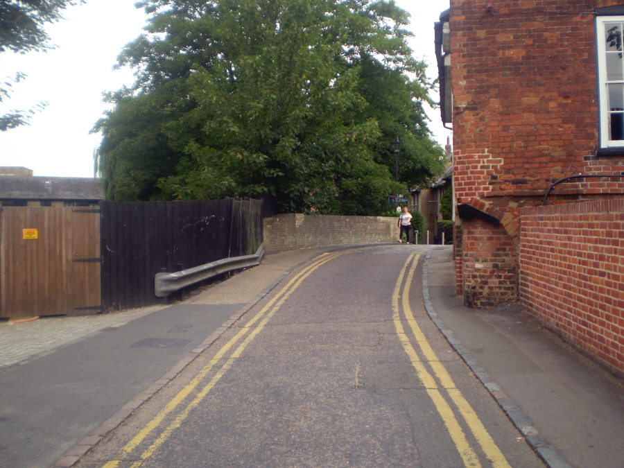
View from the Crossroads


What is quite apparent over time is that the road surface and pavements have been improved but not without the modern scourge of visitors, double yellow lines. Not so clear from the 2018 photo is the increase in the number of motor vehicles; cars were quite rare here in 1976.
The Corner Shop


This is the loss of the corner shop. It was originally at No. 2 Thornton Street, adjacent to Riverside. It ceased trading as a grocery and was for a time Island Cycles and Hertford’s buses carried its advertising. Then it was let to a chap who ran it as a pine shop but only opened on Saturday’s. It was successfully converted to a residential dwelling but the post box was lost. It was relocated to Thornton Street at the entrance to the alley between The Folly and Riverside.
In the earlier photo you can see what appears to be a gas lamp on the right hand side in front of a tree. In the photo of The Folly above one half of the lamp is missing.
Folly Bridge

Peter’s photo appears to have been taken from the side of the Hertford Club. Folly Bridge is quite visible but in a sad state of repair and notice the steps. McMullens brewery is quite clear next to the chimney (also now lost). Unfortunately today the trees mask any further detail.

This Ordnance Survey map of 1897 shows the increase in residential dwellings on the island and the height of commercial development on Little Hartham, just above ‘Folly Bridge’ and the maltings on the
This would give credence to the 1976 photo of the scene as the redundant buildings on Little Hartham were demolished in 1980 and run as Coopers Coachworks until that too moved to Mead Lane and a modern development Coopers Court erected in its place. The maltings were also converted to riverside dwellings, see below.

However the distinctive witches hat of the original maltings have not been totally carried through.
The Railway
In the top left hand corner of the OS Map you can see part of an old railway line. This was a branch of the Great Northern Line which was opened in 1858 and ran from Hertford East to Cowbridge. The latter was renamed Hertford North in 1923 but in 1924 the new Hertford Loop line was opened at the new Hertford North and the old one closed down.
The track ran parallel to the Lea and then on to Cowbridge and a sidings and goods yard. It was originally part of the line to Hatfield. The last passenger service ran in 1924 and only the goods yard remained which along with buildings was demolished in 1980.
The line ran to what is now McMullens Brewery and the only extant part is the viaduct on the west side of Port Hill, now bricked up.
For a much fuller account of the Great Northern Railway and the subsequent London and North Eastern Railway see: Disused Stations, Hertford.


It is difficult to correctly place the location of Peter Ruffles’ photo of the railway but the line has now been completely lost under tons of concrete in 1990 such as this view of Hartham Common car park. The sidings and goods yard lay beneath the brewery, a small industrial estate and lately Sainsbury’s.
One can only wonder at what changes may occur on Folly Island in the next 42 years.
More articles on Hertford:
Hertford the county town, Folly Island, Hidden Hertford, Old Barge Pub, Brewing in Hertford, Easter, Fore Street, Eccentric Clergy, Hertford Library, Hertford 1861, Tunnels of Hertford, Sarah Stout, Closed pubs